"Substantially higher"?
Huh? It would only be about .5 of a degree C averaged out wouldn't it?
When you say 31 years I assume you're talking about the satellite record. Here it is.
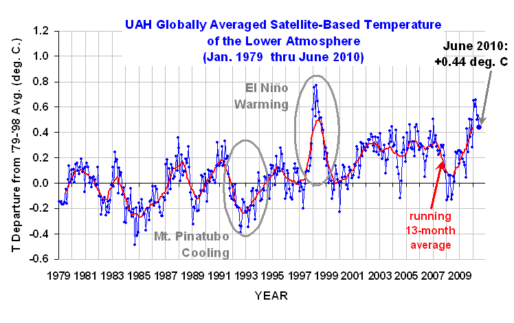
The satellite record is probably the best we have. Here's what one of the scientists (Dr. Roy Spencer) who monitors one of the satellite records says about June.
$1:
The global-average lower tropospheric temperature remains warm, +0.44 deg. C for June, 2010, but it appears the El Nino warmth is waning as a La Nina approaches.
For those keeping track of whether 2010 ends up being a record warm year, 1998 still leads with the daily average for 1 Jan to 30 June being +0.64 C in 1998 compared with +0.56 C for 2010. (John Christy says that the difference is not statistically significant.) As of 30 June 2010, there have been 181 days in the year. From our calibrated daily data, we find that 1998 was warmer than 2010 on 122 (two-thirds) of them.
http://www.drroyspencer.com/2010/07/jun ... -44-deg-c/He mentions El nino. Here's what's been happening there.
http://www.eldersweather.com.au/climimage.jsp?i=nino34There's some question about how accurate the NOAA claim for June was.
http://wattsupwiththat.com/2010/07/17/n ... pressions/The satellite record says June was warm though, but so what? As night follows day, if Spencer is correct about a coming La Nina expect the second half of 2010 to cool as we slip from El Nino into La Nina.
If that happens, don't expect hysterical newspaper articles telling you what the global temperature was this month.
Also, because we have recently shifted into a negative PDO which should last 30ish years we should expect fewer, and less powerful El Ninos (warmer), and more, and more influential La Ninas (cooler).


") CKA Uber
CKA Uber 


") CKA Elite
CKA Elite 


